Aircraft Icing Explained: Where It Forms, and Why It Is So Serious
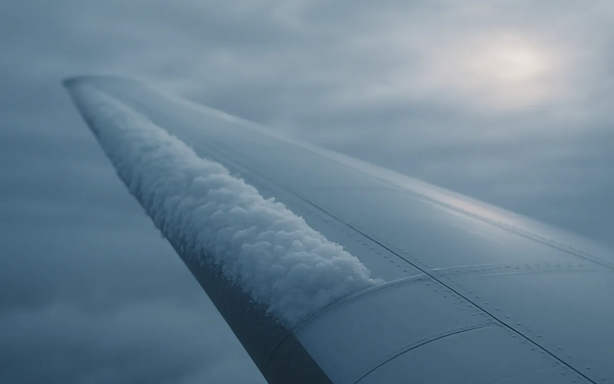
A wing does not fly because it is strong. It flies because of its shape, and that shape is engineered to within fractions of a millimetre at the leading edge. Ice ruins the shape.
That is why icing is treated with a seriousness that surprises people who imagine a bit of frost. Roughness the thickness of coarse sandpaper on a leading edge can cost a substantial fraction of the maximum lift and raise the stall speed noticeably — and the ice does not stop accumulating when it becomes inconvenient.
What actually happens#
Cloud droplets can remain liquid well below 0 °C — supercooled — and freeze the instant they strike a surface. An aircraft flying through supercooled cloud is a moving freezing surface. The droplets hit the leading edge, freeze, and build outward and backward from there. Three things follow at once, and each of them is bad on its own.
- The aerofoil shape changes, so maximum lift falls and the stall speed rises.
- Drag increases, so the aircraft needs more power to hold speed and altitude.
- Weight increases, which is the least important of the three but arrives with the others.
- Control surfaces, pitot tubes, static ports and antennas can ice, giving false or lost indications.
- Propeller or fan blade ice sheds unevenly, producing vibration.
The stall speed rise is the killer. An aircraft that stalls at an unexpectedly high speed, with degraded controls, in cloud, has very little margin left.
The three types#
| Type | Forms at | Looks like | Why it matters |
|---|---|---|---|
| Rime | −15 °C to −40 °C, small droplets | Opaque, white, rough | Builds fast on the leading edge; rough shape, easy to see |
| Clear (glaze) | 0 °C to −10 °C, large droplets | Transparent, smooth, heavy | Runs back before freezing, forms behind the de-ice boots |
| Mixed | −10 °C to −15 °C | Both, in layers | Combines the weight of clear with the roughness of rime |
Clear ice is the one that catches people out, because it is nearly invisible from the flight deck and forms aft of the protected surfaces where nothing can remove it.
The temperature band, and the moisture rule#
Two conditions have to be met at once: visible moisture, and a surface temperature at or below freezing. Without visible moisture there is nothing to freeze; without the temperature there is nothing to freeze it. The most productive band for structural icing is roughly 0 °C to −20 °C, with the worst accumulation rates around −2 °C to −10 °C where the droplets are largest.
- Below about −40 °C the cloud is already ice crystals and does not adhere.
- Between 0 °C and −20 °C is the band to plan around.
- Freezing rain and freezing drizzle can produce severe icing at temperatures at or just above 0 °C at the aircraft, because the droplets are supercooled from above.
- Engine and carburettor icing can occur well above freezing — carburettor ice is possible in warm, humid air at +20 °C.
Freezing rain deserves separate respect. It is the one situation where the correct answer is to leave the area immediately rather than manage it, because accumulation rates exceed what any protection system is certified for.
What the reports and forecasts tell you#
Icing is forecast rather than observed, and the products are separate from the METAR. AIRMETs and SIGMETs cover icing in a defined area; graphical icing forecasts show probability and severity by flight level; and the METAR contributes indirectly through the temperature, dew point and precipitation codes.
| Source | What it gives you |
|---|---|
| SIGMET (ICE) | Severe icing over a defined area and period |
| AIRMET / graphical icing forecast | Moderate icing, probability and severity by level |
| METAR FZRA / FZDZ | Freezing precipitation observed at the surface |
| METAR temperature/dew point | Saturation and freezing level clues at the aerodrome |
| Significant weather chart | Forecast icing areas at cruise levels |
| Pilot reports | The only direct observation of icing that exists |
Pilot reports matter disproportionately here. Icing is the phenomenon with the largest gap between what is forecast and what is actually encountered, and the only instrument measuring it is an aircraft.
Ground icing is a separate problem#
Frost, snow or ice on an aircraft before departure is governed by the clean aircraft principle: nothing takes off with contamination adhering to a critical surface, without exception. De-icing fluid removes what is there; anti-icing fluid buys a protected period called the holdover time, which depends on the fluid, the temperature and the precipitation rate.
- Inspect and identify the contamination type.
- De-ice — usually heated Type I fluid, which removes but does not protect.
- Anti-ice — thickened Type II or IV fluid, which protects for a calculated period.
- Start the holdover clock at the beginning of the anti-icing application.
- If the holdover time expires before takeoff, the treatment is repeated, not estimated.
Holdover tables collapse in freezing rain and heavy snow — sometimes to a few minutes — which is why those conditions produce departure gridlock rather than a slow trickle.
Reading the risk before you fly#
- Is there visible moisture along the route at the levels you will use?
- Where is the freezing level, and does the climb or descent pass through the 0 °C to −20 °C band inside cloud?
- Are FZRA or FZDZ reported anywhere near the route or the destination?
- Is the aircraft certified for flight in known icing, and is the protection system serviceable?
- Is there an escape — a level, a heading or an altitude that leaves the cloud quickly?
For an aircraft not certified for known icing, the plan is to stay out of the conditions, not to manage them. That is a route and altitude decision made on the ground.
Frequently asked questions
At what temperature does aircraft icing occur?
Structural icing needs visible moisture and a surface at or below 0 °C, and the most productive band is roughly 0 °C to −20 °C, with the highest accumulation rates around −2 °C to −10 °C where supercooled droplets are largest. Below about −40 °C the cloud consists of ice crystals that do not adhere. Freezing rain and freezing drizzle are the exception: they can produce severe icing at temperatures at or just above freezing at the aircraft, because the droplets arrive already supercooled.
Why is aircraft icing dangerous?
Because a wing is a shape, and ice changes it. Roughness on the leading edge reduces the maximum lift the wing can produce and raises the stall speed, while drag rises and weight increases. Clear ice is the most dangerous type because it is nearly invisible from the flight deck and forms behind the protected leading edge, where no de-icing system can reach it. Icing can also block pitot tubes and static ports, which corrupts the airspeed and altitude indications at the worst possible moment.
How do pilots know if icing is forecast?
Through separate products from the METAR: SIGMETs for severe icing, AIRMETs and graphical icing forecasts for moderate icing by flight level and probability, and significant weather charts for cruise levels. The METAR contributes indirectly through the temperature and dew point pair and through FZRA or FZDZ codes at the surface. Pilot reports carry unusual weight for icing, because it is the phenomenon where forecast and encountered conditions differ most and an aircraft is the only real sensor.
aircraft icingicing in flightclear ice vs rime icefreezing rain aviationde-icing holdover timeicing forecast aviation